Spatial modeling of nitrate transfer in an agricultural watershed: The Ono watershed case (Côte d’Ivoire)

Abstract
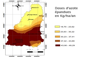
The Ono Watershed (OWB), in the South Comoé region, is dominated by agro-industrial crops using chemical fertilizers. This constitutes a major source of nitrate pollution. This study aimed to model the transfer of nitrates to the surface waters of the BVO in two steps: (i) modeling the water erosion of the area and (ii) estimating the amount of nitrogen in the BVO. The combination of these vulnerability parameters, preceded by a multi-criteria analysis, resulted in a map of the risk of nitrate transfer to surface waters. This map reveals that the Low and Very Low-Risk classes represent 65.5% of the BVO. The High-Risk classes represent 25.2% of the BVO and concern the pineapple production area of Ono-Salci near the Ono Lagoon. The Medium Risk classes occupy 9.29% of the basin and concern Bongo's rubber and oil palm production areas. Thus, this simple spatial multi-criteria analysis allowed for the simulation of the risk of nitrate transfer to surface waters in the BVO. This study could be extended by analyzing nitrates in surface water samples from the BVO.
Key words: Nitrates, Diffuse pollution, Vulnerability, Surface water, Agriculture, Pineapple crop, Agricultural watershed