Spatiotemporal variability of forage resources in the Zou watershed at Domé (Benin): Implications for sustainable land management

Abstract
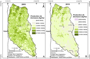
The reduction of areas suitable for grazing in the Zou Watershed Basin compromises forage resource availability and herd mobility. This study aims to analyze the spatiotemporal variability of forage resources in the Zou Watershed Basin at the Domé outlet (BVZD). The study methodology involves the use of Landsat satellite images from 1991, 2003, and 2020, with a spatial resolution of 30 meters. Biomass data, obtained via Office for the Coordination of Humanitarian Affairs (OCHA), are analyzed using Correspondence Factor Analysis to assess forage availability. The classification results of images from 1991 to 2020 reveal a significant regression, with an average conversion rate exceeding 50% of natural formations such as forests and savannas, replaced by fields, fallows, and plantations. This change was marked by a significant regression of 2,901 kg/ha in available biomass between 2003 and 2020, especially in forest and marsh areas, with potential implications for the future availability of forage for livestock. Predictive modeling suggests a continued trend of natural resource degradation until 2050, emphasizing the importance of sustainable management of pastoral resources in the BVZD.
Keywords: Spatiotemporal variability, Forage resources, Sustainable land management, Watershed, Zou