Mapping and spatio-temporal dynamics of plant formations in the protected forest of Baban Rafi (Niger)

Abstract
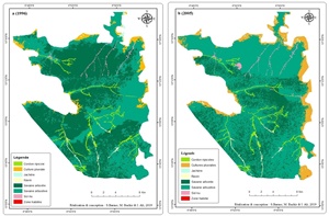
n Niger, protected areas lose several hectares of their land each year under the combined effects of anthropogenic pressure and climate change. To understand this continuous degradation of the plant cover, a study was carried out in the protected forest of Baban Rafi. The main objective of this study is to highlight the spatio-temporal dynamics of forest formations between 1996 and 2016 by means of remote sensing and Geographic Information Systems (GIS). For this purpose, an exploitation of Landsat LT05 type satellite images from 1996, Landsat LE07 from 2005 and Sentinel T32PKV for 2016 coupled with ground truth using GPS including 17 visited points. This made it possible to identify 8 types of land use: the riparian belt, the tree savannah, the shrub savannah, the rainfed crops, the fallow, the inhabited area, the bare soils and the ravine. The cartographic results also reveal a regression in forest cover in the order of 171.8 ha / year between 1996 and 2016. This regression was in favor of cultivated areas which increased by 3,450 ha. These results suggest the implementation of an effective strategy for the sustainable management of the Baban Rafi protected forest to avoid its disappearance in the long term.
Keywords: Degradation, remote sensing, dynamic, sustainable management, Baban Rafi forest, Niger